South Gloucestershire Council (SGC) and Network Rail have published further information about the expected impacts of a 21-month project to replace the old railway bridge on Gipsy Patch Lane and construct new bus lanes for the proposed Cribbs Patchway MetroBus Extension (CPME) scheme.
The latest documents were released in early June, just a few weeks before the two related planning applications are expected to be determined by SGC’s Development Control (West) Committee on 12th July.
The existing masonry railway bridge has a height clearance of only 4m and creates a ‘pinch point’ on the local road network. The replacement bridge will be of concrete construction and will span 24m, approximately 14m wider than the current bridge. To accommodate taller vehicles, such as double-decker buses, the carriageway will be lowered by approximately 1.7m as it passes under the bridge.
Demolition of the existing bridge and construction of the new bridge is now scheduled to take place during a twelve-day “possession” (closure) of the railway over Easter 2020.
A new Traffic Management Framework document provides an overview of the programme of works on Gipsy Patch Lane, with indicative durations and anticipated traffic restrictions (see table above). However, the document warns that precise details of construction and traffic management cannot be confirmed until the appointment of design and build sub-contractors for the railway bridge, following receipt of planning permission.
The document confirms that Gipsy Patch Lane will need to be fully closed for a period of approximately eight months to facilitate preparatory works, construction and follow-up works. The area of Gipsy Patch Lane to be closed would be at the railway bridge, leaving access to side roads along the rest of Gipsy Patch Lane.
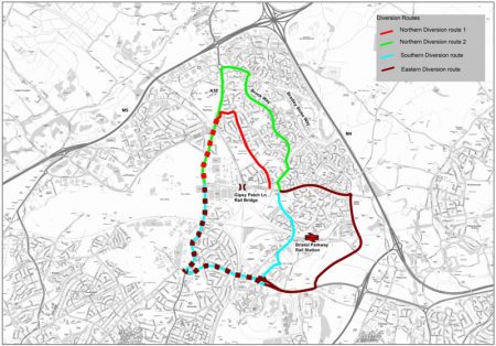
A route via Orpheus Avenue, Brook Way and Bradley Stoke Way is recommended as the main diversion for regular vehicles that normally use Gipsy Patch Lane, “given the constraints, journey lengths and junction delays [associated] with some of the other [possible] diversionary routes”. HGVs will also be diverted through Bradley Stoke, or alternatively, via Great Stoke Way, the Stoke Gifford Transport Link and the A4174.
The document states that it will not possible to provide unrestricted access for members of the public under the bridge during the main construction period and it is proposed that a shuttle bus will be provided to mitigate the impact on non-motorised users.
Asked about a recent report in the Bristol Post that the estimated cost of constructing the new bridge has doubled to £50m, an SGC spokesperson told the Journal:
“The planning application for the proposed replacement of the railway bridge was submitted in February 2018. Since this time, technical design work, which does not affect the planning application, has continued. As part of this ongoing process, a potential cost increase has been identified and we are working with Network Rail to understand the issues. We are not in a position to confirm the total cost of the scheme until this further technical work has been completed. However, any cost increase does not affect the principle of the scheme in the submitted planning application and therefore does not affect the consideration of the application at planning committee.”
Planning applications:
- PT18/0986/F | Demolition and construction of new railway bridge…
- PT18/0987/R3F | Widening of Gipsy Patch Lane…
Related links:
- Transport Assessment [8MB; PDF on Dropbox]
- Traffic Management Framework [1MB; PDF on Dropbox]
Image: CPME Gipsy Patch Lane diversion routes, from the Transport Assessment document (click to enlarge).
“The recommended diversionary route during the construction works would be the northern diversionary route 2 [shown in green in the map above].”
This article originally appeared in the July/August 2018 issue of the Bradley Stoke Journal news magazine (on pages 10 & 11). The magazine is delivered FREE, EVERY MONTH, to ALL 8,700 homes in Bradley Stoke. Phone 01454 300 400 to enquire about advertising or leaflet insertion.
UPDATE (11th July 2018)
Agenda for the meeting of the Development Control (West) Committee on 12th July
Both the above planning applications are recommended (by officers) for approval.


Should be fun when the brook floods again as it used to.